
Thank you for supporting this site ❤️
Make a donation
Make a donation
Callaway-Garrison topographic map
Click on the map to display elevation.
Thank you for supporting this site ❤️
Make a donation
Make a donation
About this map
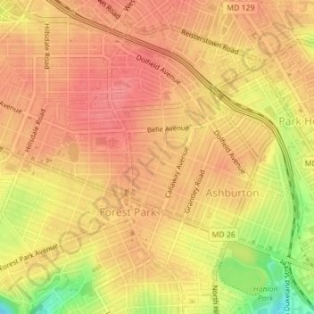
Name: Callaway-Garrison topographic map, elevation, terrain.
Location: Callaway-Garrison, Baltimore, Maryland, United States (39.32638 -76.68426 39.33560 -76.67546)
Average elevation: 124 m
Minimum elevation: 74 m
Maximum elevation: 144 m
Thank you for supporting this site ❤️
Make a donation
Make a donation
Other topographic maps
Click on a map to view its topography, its elevation and its terrain.