
Hyderabad topographic map
Interactive map
Click on the map to display elevation.
About this map
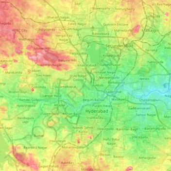
Name: Hyderabad topographic map, elevation, terrain.
Location: Hyderabad, Telangana, India (17.29313 78.38199 17.48431 78.55632)
Average elevation: 534 m
Minimum elevation: 466 m
Maximum elevation: 631 m
Other topographic maps
Click on a map to view its topography, its elevation and its terrain.
Laxmidevipally mandal
India > Telangana > Laxmidevipally mandal
Laxmidevipally mandal, Bhadradri Kothagudem, Telangana, 507101, India
Average elevation: 148 m
Shamirpet mandal
Shamirpet mandal, Medchal–Malkajgiri, Telangana, 500078, India
Average elevation: 574 m
Secunderabad
India > Telangana > Secunderabad
Secunderabad, Maredpally mandal, Hyderabad, Telangana, 500003, India
Average elevation: 544 m