
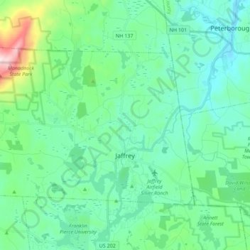
Jaffrey topographic map
Interactive map
Click on the map to display elevation.
About this map
Name: Jaffrey topographic map, elevation, terrain.
Average elevation: 351 m
Minimum elevation: 216 m
Maximum elevation: 940 m
Thorndike Pond is in the north, and Contoocook Lake is on the southern boundary. Mount Monadnock, elevation 3,165 feet (965 m) and the highest point in Jaffrey as well as Cheshire County, is in the northwest. Jaffrey lies mostly within the Merrimack River watershed, via the Contoocook River in the eastern part of the town, with the northwest corner of town lying in the Ashuelot River watershed, part of the larger Connecticut River watershed.
Other topographic maps
Click on a map to view its topography, its elevation and its terrain.
East Alstead
United States > New Hampshire > Cheshire County > Alstead
East Alstead, Alstead, Cheshire County, New Hampshire, 03607, United States
Average elevation: 418 m
Troy
United States > New Hampshire > Cheshire County
Troy, Cheshire County, New Hampshire, 03465, United States
Average elevation: 374 m
Munsonville
United States > New Hampshire > Cheshire County > Nelson
Munsonville, Nelson, Cheshire County, New Hampshire, 03457, United States
Average elevation: 425 m
Sullivan
United States > New Hampshire > Cheshire County
Sullivan, Cheshire County, New Hampshire, 03445, United States
Average elevation: 379 m
West Swanzey
United States > New Hampshire > Cheshire County > Swanzey
West Swanzey, Swanzey, Cheshire County, New Hampshire, 03446, United States
Average elevation: 177 m
Chesham
United States > New Hampshire > Cheshire County > Harrisville
Chesham, Harrisville, Cheshire County, New Hampshire, United States
Average elevation: 392 m
East Swanzey
United States > New Hampshire > Cheshire County > Swanzey
East Swanzey, Swanzey, Cheshire County, New Hampshire, 03446, United States
Average elevation: 197 m
Drewsville
United States > New Hampshire > Cheshire County > Walpole
Drewsville, Walpole, Cheshire County, New Hampshire, 03604, United States
Average elevation: 182 m
Poocham
United States > New Hampshire > Cheshire County > Westmoreland
Poocham, Westmoreland, Cheshire County, New Hampshire, United States
Average elevation: 223 m
North Walpole
United States > New Hampshire > Cheshire County > Walpole
North Walpole, Walpole, Cheshire County, New Hampshire, 03609, United States
Average elevation: 168 m
Ashuelot
United States > New Hampshire > Cheshire County > Winchester
Ashuelot, Winchester, Cheshire County, New Hampshire, 03441, United States
Average elevation: 209 m
West Chesterfield
United States > New Hampshire > Cheshire County > Chesterfield
West Chesterfield, Chesterfield, Cheshire County, New Hampshire, 03466, United States
Average elevation: 168 m
Surry
United States > New Hampshire > Cheshire County
Surry, Cheshire County, New Hampshire, United States
Average elevation: 309 m
Camp Notre Dame
United States > New Hampshire > Cheshire County > Chesterfield
Camp Notre Dame, Chesterfield, Cheshire County, New Hampshire, 03462, United States
Average elevation: 223 m
Mount Monadnock
United States > New Hampshire > Cheshire County > Jaffrey
Mount Monadnock, Jaffrey, Cheshire County, New Hampshire, United States
Average elevation: 687 m
Rindge
United States > New Hampshire > Cheshire County
Rindge, Cheshire County, New Hampshire, United States
Average elevation: 343 m
Keene
United States > New Hampshire > Cheshire County
Keene, Cheshire County, New Hampshire, United States
Average elevation: 263 m
Hinsdale
United States > New Hampshire > Cheshire County
Hinsdale, Cheshire County, New Hampshire, 03451, United States
Average elevation: 193 m
Richmond
United States > New Hampshire > Cheshire County
Richmond, Cheshire County, New Hampshire, United States
Average elevation: 321 m
Westmoreland
United States > New Hampshire > Cheshire County
Westmoreland, Cheshire County, New Hampshire, 03467, United States
Average elevation: 228 m
Longmeadow Subdivision
United States > New Hampshire > Cheshire County > Keene
Longmeadow Subdivision, Keene, Cheshire County, New Hampshire, 03431, United States
Average elevation: 179 m
Spofford
United States > New Hampshire > Cheshire County > Chesterfield
Spofford, Chesterfield, Cheshire County, New Hampshire, 03462, United States
Average elevation: 262 m
Swanzey
United States > New Hampshire > Cheshire County
Swanzey, Cheshire County, New Hampshire, United States
Average elevation: 243 m
Fitzwilliam
United States > New Hampshire > Cheshire County
Fitzwilliam, Cheshire County, New Hampshire, 03447, United States
Average elevation: 348 m
Maple Acres
United States > New Hampshire > Cheshire County > Keene
Maple Acres, Keene, Cheshire County, New Hampshire, 03431, United States
Average elevation: 174 m
Lower Village
United States > New Hampshire > Cheshire County > Gilsum
Lower Village, Gilsum, Cheshire County, New Hampshire, 03448, United States
Average elevation: 323 m
Walpole
United States > New Hampshire > Cheshire County
Walpole, Cheshire County, New Hampshire, United States
Average elevation: 240 m
Alstead Center
United States > New Hampshire > Cheshire County > Alstead > Alstead Center
Alstead Center, Alstead, Cheshire County, New Hampshire, 03602, United States
Average elevation: 371 m
Pisgah State Park
United States > New Hampshire > Cheshire County > Winchester
Pisgah State Park, Winchester, Cheshire County, New Hampshire, United States
Average elevation: 250 m
Scotland
United States > New Hampshire > Cheshire County > Winchester > Scotland
Scotland, Winchester, Cheshire County, New Hampshire, 03470, United States
Average elevation: 209 m
Winchester
United States > New Hampshire > Cheshire County > Winchester
Winchester, Cheshire County, New Hampshire, United States
Average elevation: 167 m
Marlow
United States > New Hampshire > Cheshire County
Marlow, Cheshire County, New Hampshire, 03456, United States
Average elevation: 446 m
West River
United States > New Hampshire > Cheshire County
West River, Cheshire County, New Hampshire, 05357, United States
Average elevation: 429 m
Gilsum
United States > New Hampshire > Cheshire County
Gilsum, Cheshire County, New Hampshire, 03448, United States
Average elevation: 349 m
Alstead
United States > New Hampshire > Cheshire County
Alstead, Cheshire County, New Hampshire, United States
Average elevation: 289 m
Stoddard
United States > New Hampshire > Cheshire County
Stoddard, Cheshire County, New Hampshire, United States
Average elevation: 451 m
Keene
United States > New Hampshire > Cheshire County > Keene
Keene, Cheshire County, New Hampshire, 03435, United States
Average elevation: 314 m
Nelson
United States > New Hampshire > Cheshire County
Nelson, Cheshire County, New Hampshire, 03457, United States
Average elevation: 454 m
Marlborough
United States > New Hampshire > Cheshire County
Marlborough, Cheshire County, New Hampshire, 03455, United States
Average elevation: 301 m
Chesterfield
United States > New Hampshire > Cheshire County
Chesterfield, Cheshire County, New Hampshire, United States
Average elevation: 229 m
Dublin
United States > New Hampshire > Cheshire County
Dublin, Cheshire County, New Hampshire, 03444, United States
Average elevation: 400 m
Roxbury
United States > New Hampshire > Cheshire County
Roxbury, Cheshire County, New Hampshire, United States
Average elevation: 379 m
Harrisville
United States > New Hampshire > Cheshire County
Harrisville, Cheshire County, New Hampshire, 03450, United States
Average elevation: 422 m