
Keene topographic map
Interactive map
Click on the map to display elevation.
About this map
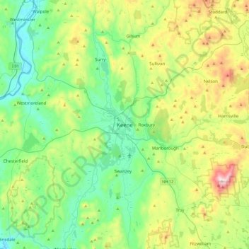
Name: Keene topographic map, elevation, terrain.
Location: Keene, Cheshire County, New Hampshire, 03435, United States (42.77360 -72.43843 43.09360 -72.11843)
Average elevation: 314 m
Minimum elevation: 59 m
Maximum elevation: 949 m
Other topographic maps
Click on a map to view its topography, its elevation and its terrain.
Longmeadow Subdivision
United States > New Hampshire > Cheshire County > Keene
Longmeadow Subdivision, Keene, Cheshire County, New Hampshire, 03431, United States
Average elevation: 179 m
Maple Acres
United States > New Hampshire > Cheshire County > Keene
Maple Acres, Keene, Cheshire County, New Hampshire, 03431, United States
Average elevation: 174 m