
Western Downs Regional topographic map
Interactive map
Click on the map to display elevation.
About this map
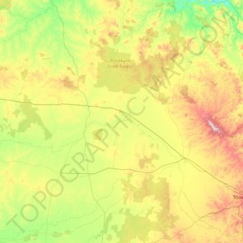
Name: Western Downs Regional topographic map, elevation, terrain.
Location: Western Downs Regional, 昆士兰州, 澳大利亚 (-28.01458 149.09727 -25.59892 151.67450)
Average elevation: 338 m
Minimum elevation: 105 m
Maximum elevation: 1,091 m
Other topographic maps
Click on a map to view its topography, its elevation and its terrain.
Redland Bay
Redland Bay, Greater Brisbane, Redland City, 昆士兰州, 4165, 澳大利亚
Average elevation: 17 m
North Lakes
North Lakes, Greater Brisbane, Moreton Bay Regional, 昆士兰州, 4509, 澳大利亚
Average elevation: 19 m
Stanthorpe
澳大利亚 > 昆士兰州 > Stanthorpe
Stanthorpe, Southern Downs Regional, 昆士兰州, 4380, 澳大利亚
Average elevation: 840 m