
Dakenba topographic map
Interactive map
Click on the map to display elevation.
About this map
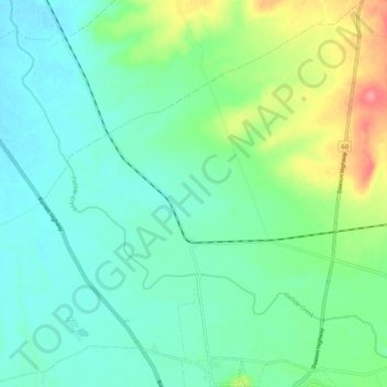
Name: Dakenba topographic map, elevation, terrain.
Location: Dakenba, Banana Shire, 昆士兰州, 澳大利亚 (-24.38717 150.45669 -24.29170 150.54339)
Average elevation: 176 m
Minimum elevation: 154 m
Maximum elevation: 236 m
Other topographic maps
Click on a map to view its topography, its elevation and its terrain.
Redland Bay
Redland Bay, Greater Brisbane, Redland City, 昆士兰州, 4165, 澳大利亚
Average elevation: 17 m
North Lakes
North Lakes, Greater Brisbane, Moreton Bay Regional, 昆士兰州, 4509, 澳大利亚
Average elevation: 19 m
Stanthorpe
澳大利亚 > 昆士兰州 > Stanthorpe
Stanthorpe, Southern Downs Regional, 昆士兰州, 4380, 澳大利亚
Average elevation: 840 m