
Sukawati topographic map
Interactive map
Click on the map to display elevation.
About this map
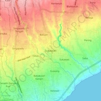
Name: Sukawati topographic map, elevation, terrain.
Location: Sukawati, Gianyar, Bali, Nusa Tenggara, 80582, Indonesien (-8.63615 115.24204 -8.55615 115.32204)
Average elevation: 62 m
Minimum elevation: 0 m
Maximum elevation: 132 m
Other topographic maps
Click on a map to view its topography, its elevation and its terrain.
Lod Sema
Indonesien > Bali > Gianyar > Pujung
Lod Sema, Pujung, Gianyar, Bali, Nusa Tenggara, 80572, Indonesien
Average elevation: 569 m
Tampak Siring
Indonesien > Bali > Gianyar
Tampak Siring, Gianyar, Bali, 80661, Indonesien
Average elevation: 497 m
Petulu
Indonesien > Bali > Gianyar
Petulu, Ubud, Gianyar, Bali, 80571, Indonesien
Average elevation: 299 m
Taman Desa Sayan
Indonesien > Bali > Gianyar > Ubud
Taman Desa Sayan, Ubud, Gianyar, Bali, 80571, Indonesien
Average elevation: 179 m
Ubud
Indonesien > Bali > Gianyar
Ubud, Gianyar, Bali, Nusa Tenggara, 80571, Indonesien
Average elevation: 215 m