
Tampak Siring topographic map
Interactive map
Click on the map to display elevation.
About this map
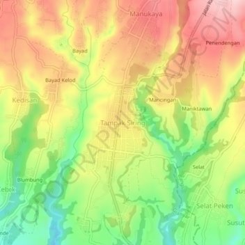
Name: Tampak Siring topographic map, elevation, terrain.
Location: Tampak Siring, Gianyar, Bali, 80661, Indonesien (-8.44519 115.28902 -8.40519 115.32902)
Average elevation: 497 m
Minimum elevation: 384 m
Maximum elevation: 600 m
Die Bewohner des in 630 m Höhe gelegenen Ortes sind bekannt für ihre kunstvollen Holzschnitzereien, die man hier erwerben kann, die aber auch die Pavillons im Ortstempel (Pura Desa) zieren.
Other topographic maps
Click on a map to view its topography, its elevation and its terrain.
Lod Sema
Indonesien > Bali > Gianyar > Pujung
Lod Sema, Pujung, Gianyar, Bali, Nusa Tenggara, 80572, Indonesien
Average elevation: 569 m
Sukawati
Indonesien > Bali > Gianyar
Sukawati, Gianyar, Bali, Nusa Tenggara, 80582, Indonesien
Average elevation: 62 m
Petulu
Indonesien > Bali > Gianyar
Petulu, Ubud, Gianyar, Bali, 80571, Indonesien
Average elevation: 299 m
Taman Desa Sayan
Indonesien > Bali > Gianyar > Ubud
Taman Desa Sayan, Ubud, Gianyar, Bali, 80571, Indonesien
Average elevation: 179 m
Ubud
Indonesien > Bali > Gianyar
Ubud, Gianyar, Bali, Nusa Tenggara, 80571, Indonesien
Average elevation: 215 m