
Make a donation
Coulter topographic map
Click on the map to display elevation.
Make a donation
About this map
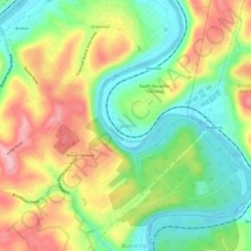
Name: Coulter topographic map, elevation, terrain.
Average elevation: 287 m
Minimum elevation: 219 m
Maximum elevation: 373 m
Make a donation
Other topographic maps
Click on a map to view its topography, its elevation and its terrain.
Brackenridge
United States > Pennsylvania > Allegheny County
Brackenridge is located at 40°36′30″N 79°44′32″W / 40.60833°N 79.74222°W / 40.60833; -79.74222. The borough's average elevation is 827 feet (252 m) above sea level. According to the U.S. Census Bureau, the borough has a total area of 0.6 square miles (1.6 km2), of which 0.5 square miles…
Average elevation: 266 m
Make a donation
Russellton
United States > Pennsylvania > Allegheny County > West Deer Township
Average elevation: 325 m
Make a donation
Curtisville
United States > Pennsylvania > Allegheny County > West Deer Township > Curtisville
Average elevation: 344 m
Make a donation
Make a donation
Make a donation
Make a donation
Make a donation
Bradford Woods
United States > Pennsylvania > Allegheny County
According to the United States Census Bureau, the borough has a total area of 0.9 square miles (2.3 km2), all of it land. Its average elevation is 1,250 ft (381 m) above sea level.
Average elevation: 369 m
Avalon
United States > Pennsylvania > Allegheny County
According to the United States Census Bureau, the borough has a total area of 0.7 square miles (1.8 km2), of which 0.6 square miles (1.6 km2) is land and 0.1 square miles (0.26 km2) is water. Its average elevation is 932 feet (284 m) above sea level.
Average elevation: 275 m
Make a donation
Baldwin
United States > Pennsylvania > Allegheny County
According to the U.S. Census Bureau, the borough has a total area of 5.9 square miles (15 km2), of which 5.8 square miles (15 km2) is land and 0.1 square miles (0.26 km2) is water. Its average elevation is 1,214 feet (370 m) above sea level.
Average elevation: 338 m
Ben Avon
United States > Pennsylvania > Allegheny County
Its average elevation is 928 feet (283 m) above sea level.
Average elevation: 263 m
Ben Avon Heights
United States > Pennsylvania > Allegheny County
According to the United States Census Bureau, the borough has a total area of 0.2 square miles (0.52 km2), all land. Its average elevation is 1,135 feet (346 m) above sea level.
Average elevation: 294 m
Make a donation
Aspinwall
United States > Pennsylvania > Allegheny County
Aspinwall is located at 40°29′35″N 79°54′11″W / 40.49306°N 79.90306°W / 40.49306; -79.90306. According to the U.S. Census Bureau, the borough has a total area of 0.4 square miles (1.0 km2), of which 0.3 square miles (0.78 km2) is land and 0.04 square miles (0.10 km2) is water. Its average…
Average elevation: 275 m
South Park
United States > Pennsylvania > Allegheny County > South Park Township
Average elevation: 335 m
South Fayette Township
United States > Pennsylvania > Allegheny County
According to the United States Census Bureau, the township has a total area of 20.4 square miles (53 km2), of which 20.95 square miles (54.3 km2) is land and 0.05% is water. The topography is mostly wooded with small hills and floodplains on four streams. It is located 14 miles (23 km) southwest of Pittsburgh.
Average elevation: 328 m
Make a donation
Blawnox
United States > Pennsylvania > Allegheny County
According to the United States Census Bureau, the borough has a total area of 0.4 square miles (1.0 km2), of which 0.3 square miles (0.78 km2) is land and 0.1 square miles (0.26 km2), or 25.58%, is water. Its average elevation is 843 feet (257 m) above sea level.
Average elevation: 265 m
Make a donation
Bell Acres
United States > Pennsylvania > Allegheny County
According to the United States Census Bureau, the borough has a total area of 5.2 square miles (13 km2), all land. Its average elevation is 965 feet (294 m) above sea level.
Average elevation: 316 m
Make a donation
Panther Hollow Lake
United States > Pennsylvania > Allegheny County > Pittsburgh
Average elevation: 286 m
Make a donation
Allegheny Islands State Park
United States > Pennsylvania > Allegheny County > Plum > Acmetonia
Average elevation: 259 m
Make a donation
Make a donation
Make a donation
Castle Shannon
United States > Pennsylvania > Allegheny County
According to the United States Census Bureau, the borough has a total area of 1.6 square miles (4.1 km2), all of it land. Its average elevation is 1,040 feet (320 m) above sea level.
Average elevation: 354 m
Forward Township
United States > Pennsylvania > Allegheny County > Forward Township
Average elevation: 306 m
Make a donation