
Make a donation
Bell Acres topographic map
Click on the map to display elevation.
Make a donation
Bell Acres
According to the United States Census Bureau, the borough has a total area of 5.2 square miles (13 km2), all land. Its average elevation is 965 feet (294 m) above sea level.
Make a donation
About this map
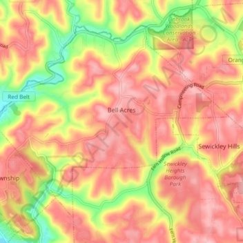
Name: Bell Acres topographic map, elevation, terrain.
Location: Bell Acres, Allegheny County, Pennsylvania, United States (40.56507 -80.20763 40.60962 -80.13365)
Average elevation: 316 m
Minimum elevation: 218 m
Maximum elevation: 375 m
Make a donation
Other topographic maps
Click on a map to view its topography, its elevation and its terrain.
Morgan
United States > Pennsylvania > Allegheny County > South Fayette Township
Average elevation: 314 m
Rural Ridge
United States > Pennsylvania > Allegheny County > Indiana Township
Average elevation: 329 m
Make a donation
Cuddy Hill
United States > Pennsylvania > Allegheny County > South Fayette Township
Average elevation: 328 m
Rennerdale
United States > Pennsylvania > Allegheny County > Collier Township
Average elevation: 321 m
Noblestown
United States > Pennsylvania > Allegheny County > North Fayette Township
Average elevation: 332 m
Make a donation
Industry
United States > Pennsylvania > Allegheny County > Elizabeth Township
Average elevation: 292 m
Greenock
United States > Pennsylvania > Allegheny County > Elizabeth Township
Average elevation: 288 m
Enlow
United States > Pennsylvania > Allegheny County > North Fayette Township
Average elevation: 329 m
Make a donation
Dorseyville
United States > Pennsylvania > Allegheny County > Indiana Township
Average elevation: 325 m
Allison Park
United States > Pennsylvania > Allegheny County > Hampton Township
Average elevation: 324 m
Bairdford
United States > Pennsylvania > Allegheny County > West Deer Township
Average elevation: 329 m
Make a donation
Buena Vista
United States > Pennsylvania > Allegheny County > Elizabeth Township
Average elevation: 291 m
Make a donation
Make a donation
Make a donation
Panther Hollow Lake
United States > Pennsylvania > Allegheny County > Pittsburgh
Average elevation: 286 m
Santiago
United States > Pennsylvania > Allegheny County > North Fayette Township
Average elevation: 354 m
Make a donation
Lovedale
United States > Pennsylvania > Allegheny County > Elizabeth Township
Average elevation: 298 m
Mount Vernon
United States > Pennsylvania > Allegheny County > Elizabeth Township
Average elevation: 299 m
Make a donation
Talley Cavey
United States > Pennsylvania > Allegheny County > Hampton Township
Average elevation: 341 m
Piney Fork
United States > Pennsylvania > Allegheny County > South Park Township
Average elevation: 325 m
Make a donation
Fox Ridge
United States > Pennsylvania > Allegheny County > McCandless > Fox Ridge
Average elevation: 349 m
Black mulberry (Morus nigra)
United States > Pennsylvania > Allegheny County > Pittsburgh
Average elevation: 296 m
Make a donation