
Thank you for supporting this site ❤️
Make a donation
Make a donation
Brunot Island topographic map
Click on the map to display elevation.
Thank you for supporting this site ❤️
Make a donation
Make a donation
About this map
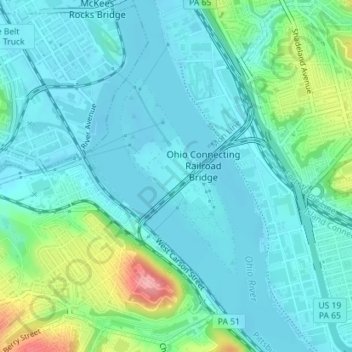
Name: Brunot Island topographic map, elevation, terrain.
Average elevation: 241 m
Minimum elevation: 216 m
Maximum elevation: 338 m
Thank you for supporting this site ❤️
Make a donation
Make a donation
Other topographic maps
Click on a map to view its topography, its elevation and its terrain.
Thank you for supporting this site ❤️
Make a donation
Make a donation
Black mulberry (Morus nigra)
United States > Pennsylvania > Allegheny County > Pittsburgh
Average elevation: 296 m
Thank you for supporting this site ❤️
Make a donation
Make a donation