
Democratic Republic of the Congo topographic map
Interactive map
Click on the map to display elevation.
Democratic Republic of the Congo
The tropical climate also produced the Congo River system which dominates the region topographically along with the rainforest it flows through, though they are not mutually exclusive. The name for the Congo state is derived in part from the river. The river basin (meaning the Congo River and all of its myriad tributaries) occupies nearly the entire country and an area of nearly 1,000,000 km2 (390,000 sq mi). The river and its tributaries form the backbone of Congolese economics and transportation. Major tributaries include the Kasai, Sangha, Ubangi, Ruzizi, Aruwimi, and Lulonga.
About this map
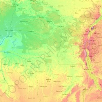
Name: Democratic Republic of the Congo topographic map, elevation, terrain.
Location: Democratic Republic of the Congo (-9.98143 16.82226 4.01857 30.82226)
Average elevation: 717 m
Minimum elevation: 287 m
Maximum elevation: 4,311 m
Other topographic maps
Click on a map to view its topography, its elevation and its terrain.
Kinshasa
Democratic Republic of the Congo > Kinshasa
Geographically covering 9,965 square kilometers, Kinshasa stretches along the southern shores of the Pool Malebo, forming an expansive crescent across flat, low-lying terrain at an average altitude of about 300 meters. Situated between latitudes 4° and 5° and longitudes East 15° and 16°32, Kinshasa shares…
Average elevation: 316 m