
Alameda County topographic map
Interactive map
Click on the map to display elevation.
About this map
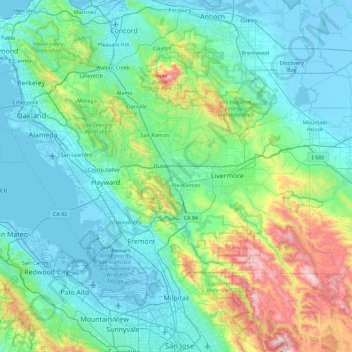
Name: Alameda County topographic map, elevation, terrain.
Location: Alameda County, California, United States (37.45426 -122.37384 37.90669 -121.46909)
Average elevation: 219 m
Minimum elevation: -7 m
Maximum elevation: 1,291 m
Other topographic maps
Click on a map to view its topography, its elevation and its terrain.
Mount Shasta
United States > California > Siskiyou County
Mount Shasta (/ˈʃæstə/ SHASS-tə; Shasta: Waka-nunee-Tuki-wuki; Karuk: Úytaahkoo) is a potentially active stratovolcano at the southern end of the Cascade Range in Siskiyou County, California. At an elevation of 14,179 ft (4,322 m), it is the second-highest peak in the Cascades and the fifth-highest in…
Average elevation: 3,717 m
Elk Creek
United States > California > Glenn County > Elk Creek
Elk Creek is a census-designated place in Glenn County, California. It is located 19 miles (31 km) northwest of Willows, at an elevation of 745 feet (227 m).
Average elevation: 258 m