Geolocate

嵊山岛 topographic map

Interactive map

Click on the map to display elevation.

About this map

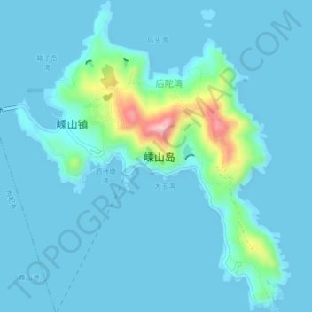
Name: 嵊山岛 topographic map, elevation, terrain.

Location: 嵊山岛, 嵊泗县, 舟山市, 浙江省, 中国 (30.70255 122.80060 30.73517 122.83337)

Average elevation: 22 m

Minimum elevation: 0 m

Maximum elevation: 206 m

Other topographic maps

Click on a map to view its topography, its elevation and its terrain.

庙子湖岛

中国 > 浙江省 > 舟山市

庙子湖岛, 舟山市, 浙江省, 中国

Average elevation: 2 m

东福山岛

中国 > 浙江省 > 舟山市

东福山岛, 舟山市, 浙江省, 中国

Average elevation: 1 m

孙家老屋里

中国 > 浙江省 > 舟山市

孙家老屋里, 舟山市, 浙江省, 中国

Average elevation: 100 m

老虎山

中国 > 浙江省 > 舟山市

老虎山, 舟山市, 浙江省, 中国

Average elevation: 150 m

沈家门街道

中国 > 浙江省 > 舟山市 > 沈家门街道

沈家门街道, 普陀区, 舟山市, 浙江省, 中国

Average elevation: 15 m

佛顶山

中国 > 浙江省 > 舟山市

佛顶山, 舟山市, 浙江省, 中国

Average elevation: 53 m

金塘岛

中国 > 浙江省 > 舟山市

金塘岛, 定海区, 舟山市, 浙江省, 中国

Average elevation: 26 m

册子岛

中国 > 浙江省 > 舟山市

册子岛, 舟山市, 浙江省, 中国

Average elevation: 19 m