Geolocate

佛顶山 topographic map

Interactive map

Click on the map to display elevation.

About this map

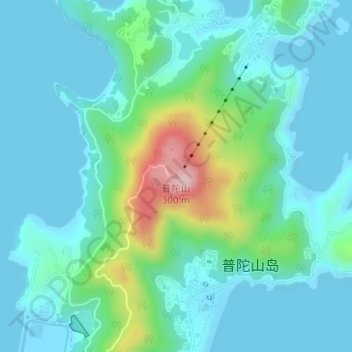
Name: 佛顶山 topographic map, elevation, terrain.

Location: 佛顶山, 舟山市, 浙江省, 中国 (30.01124 122.38627 30.01134 122.38637)

Average elevation: 53 m

Minimum elevation: 0 m

Maximum elevation: 278 m

普陀山位于杭州湾出口以东约100海里处,全岛面积仅12.5平方公里(其中陆地面积11.85平方公里,余为潮间带),呈狭长形。最高处为佛顶山,海拔约300米。

Wikipedia (CC-BY-SA 3.0)

Other topographic maps

Click on a map to view its topography, its elevation and its terrain.

庙子湖岛

中国 > 浙江省 > 舟山市

庙子湖岛, 舟山市, 浙江省, 中国

Average elevation: 2 m

东福山岛

中国 > 浙江省 > 舟山市

东福山岛, 舟山市, 浙江省, 中国

Average elevation: 1 m

孙家老屋里

中国 > 浙江省 > 舟山市

孙家老屋里, 舟山市, 浙江省, 中国

Average elevation: 100 m

老虎山

中国 > 浙江省 > 舟山市

老虎山, 舟山市, 浙江省, 中国

Average elevation: 150 m

嵊山岛

中国 > 浙江省 > 舟山市

嵊山岛, 嵊泗县, 舟山市, 浙江省, 中国

Average elevation: 22 m

沈家门街道

中国 > 浙江省 > 舟山市 > 沈家门街道

沈家门街道, 普陀区, 舟山市, 浙江省, 中国

Average elevation: 15 m

金塘岛

中国 > 浙江省 > 舟山市

金塘岛, 定海区, 舟山市, 浙江省, 中国

Average elevation: 26 m

册子岛

中国 > 浙江省 > 舟山市

册子岛, 舟山市, 浙江省, 中国

Average elevation: 19 m