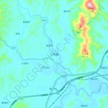
Geolocate

三甲镇 topographic map

Interactive map

Click on the map to display elevation.

About this map

Name: 三甲镇 topographic map, elevation, terrain.

Location: 三甲镇, 阳春市, 阳江市, 广东省, 中国 (22.02442 111.46525 22.10442 111.54525)

Average elevation: 75 m

Minimum elevation: 16 m

Maximum elevation: 496 m

Other topographic maps

Click on a map to view its topography, its elevation and its terrain.

春城街道

中国 > 广东省 > 阳春市

春城街道, 阳春市, 阳江市, 广东省, 中国

Average elevation: 58 m

春湾镇

中国 > 广东省 > 阳春市

春湾镇, 阳春市, 阳江市, 广东省, 中国

Average elevation: 64 m

阳春市

中国 > 广东省 > 阳春市

阳春市, 阳江市, 广东省, 中国

Average elevation: 112 m

永宁镇

中国 > 广东省 > 阳春市

永宁镇, 阳春市, 阳江市, 广东省, 中国

Average elevation: 281 m

三岸村

中国 > 广东省 > 阳春市

三岸村, 阳春市, 阳江市, 广东省, 中国

Average elevation: 268 m

司马村

中国 > 广东省 > 阳春市 > 河塱镇

司马村, 河塱镇, 阳春市, 阳江市, 广东省, 中国

Average elevation: 238 m

牛村

中国 > 广东省 > 阳春市

牛村, 阳春市, 阳江市, 广东省, 中国

Average elevation: 225 m

岗美镇

中国 > 广东省 > 阳春市

岗美镇, 阳春市, 阳江市, 广东省, 中国

Average elevation: 26 m