
右所镇 topographic map
Interactive map
Click on the map to display elevation.
About this map
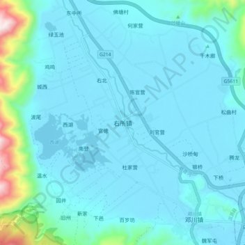
Name: 右所镇 topographic map, elevation, terrain.
Location: 右所镇, 洱源县, 大理白族自治州, 云南省, 中国 (25.98333 100.02141 26.06333 100.10141)
Average elevation: 2,042 m
Minimum elevation: 1,964 m
Maximum elevation: 2,710 m
右所镇位于中国云南省大理州洱源县东南部,北距洱源县城茈碧湖镇18公里。东与鹤庆县西邑镇、黄坪镇相临,南与邓川镇、大理市上关镇接壤,西与凤羽镇相邻,北与茈碧湖镇、三营镇相接。镇政府驻右所村,位于洱源西湖以东约1公里处,海拔1,971米。全镇总面积302.43平方公里,2002年末全镇总人口为51,956人。
Other topographic maps
Click on a map to view its topography, its elevation and its terrain.