
Thank you for supporting this site ❤️
Make a donation
Make a donation
Wijchmaal topographic map
Click on the map to display elevation.
Thank you for supporting this site ❤️
Make a donation
Make a donation
About this map
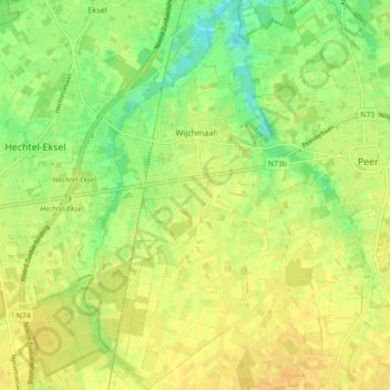
Name: Wijchmaal topographic map, elevation, terrain.
Location: Wijchmaal, Peer, Maaseik, Limburg, Vlaanderen, België (51.09893 5.38921 51.15521 5.43665)
Average elevation: 63 m
Minimum elevation: 48 m
Maximum elevation: 72 m
Thank you for supporting this site ❤️
Make a donation
Make a donation
Other topographic maps
Click on a map to view its topography, its elevation and its terrain.