
Thank you for supporting this site ❤️
Make a donation
Make a donation
Wauberg topographic map
Click on the map to display elevation.
Thank you for supporting this site ❤️
Make a donation
Make a donation
About this map
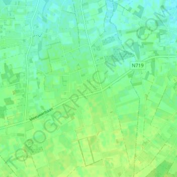
Name: Wauberg topographic map, elevation, terrain.
Location: Wauberg, Peer, Maaseik, Limburg, Vlaanderen, 3990, België (51.06513 5.44656 51.10513 5.48656)
Average elevation: 73 m
Minimum elevation: 66 m
Maximum elevation: 78 m
Thank you for supporting this site ❤️
Make a donation
Make a donation