
Thank you for supporting this site ❤️
Make a donation
Make a donation
Linde topographic map
Click on the map to display elevation.
Thank you for supporting this site ❤️
Make a donation
Make a donation
About this map
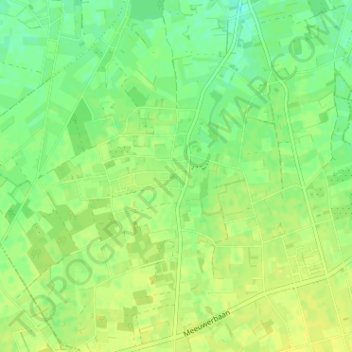
Name: Linde topographic map, elevation, terrain.
Location: Linde, Peer, Maaseik, Limburg, 3990, België (51.07605 5.42398 51.11605 5.46398)
Average elevation: 70 m
Minimum elevation: 60 m
Maximum elevation: 77 m
Thank you for supporting this site ❤️
Make a donation
Make a donation
Other topographic maps
Click on a map to view its topography, its elevation and its terrain.
Thank you for supporting this site ❤️
Make a donation
Make a donation
Kleine-Brogel
België > Limburg > Maaseik > Peer
Kleine-Brogel ligt op de noordflank van het Kempens Plateau, op een hoogte tot 60 meter. In het westen vindt men het dal van de Dommel, op welke rivier ook een aantal watermolens te vinden zijn, namelijk Kleine Molen en Wedelse Molen, welke echter tot de gemeente Pelt behoren.
Average elevation: 52 m