
马峦街道 topographic map
Interactive map
Click on the map to display elevation.
About this map
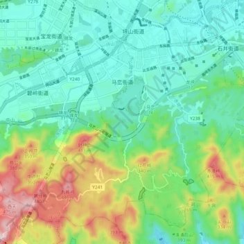
Name: 马峦街道 topographic map, elevation, terrain.
Location: 马峦街道, 坪山区, 深圳市, 广东省, 中国 (22.62495 114.29355 22.69895 114.38597)
Average elevation: 143 m
Minimum elevation: 3 m
Maximum elevation: 494 m
Other topographic maps
Click on a map to view its topography, its elevation and its terrain.