
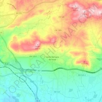
Santa Bárbara de Nexe topographic map
Interactive map
Click on the map to display elevation.
About this map
Name: Santa Bárbara de Nexe topographic map, elevation, terrain.
Location: Santa Bárbara de Nexe, Faro, Portugal (37.07289 -8.00649 37.14578 -7.90850)
Average elevation: 160 m
Minimum elevation: 17 m
Maximum elevation: 370 m
Other topographic maps
Click on a map to view its topography, its elevation and its terrain.
Alcaria Cova
Alcaria Cova, Conceição e Estoi, Faro, 8005-405, Portugal
Average elevation: 181 m
Bela Curral
Bela Curral, Conceição e Estoi, Faro, 8005-418, Portugal
Average elevation: 30 m
Areal Gordo
Areal Gordo, Faro (Sé e São Pedro), Faro, 8005-409, Portugal
Average elevation: 19 m
Quinta das Raposeiras
Portugal > Faro > Faro > Quinta das Raposeiras
Quinta das Raposeiras, Santa Bárbara de Nexe, Faro, 8005-423, Portugal
Average elevation: 256 m
Praia da Ilha de Faro
Portugal > Faro > Faro > Almancil
Praia da Ilha de Faro, Almancil, Faro, Loulé, Faro, Portugal
Average elevation: 1 m