
Thank you for supporting this site ❤️
Make a donation
Make a donation
Bela Curral topographic map
Click on the map to display elevation.
Thank you for supporting this site ❤️
Make a donation
Make a donation
About this map
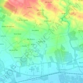
Name: Bela Curral topographic map, elevation, terrain.
Location: Bela Curral, Conceição e Estoi, Faro, 8005-418, Portugal (37.02234 -7.90859 37.06234 -7.86859)
Average elevation: 30 m
Minimum elevation: 1 m
Maximum elevation: 90 m
Thank you for supporting this site ❤️
Make a donation
Make a donation
Other topographic maps
Click on a map to view its topography, its elevation and its terrain.