
竹園聯合村 topographic map
Interactive map
Click on the map to display elevation.
About this map
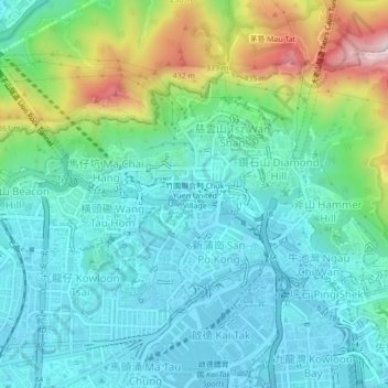
Name: 竹園聯合村 topographic map, elevation, terrain.
Location: 竹園聯合村, 黃大仙區, 九龍, 香港, 000000, 中国 (22.32247 114.17575 22.36247 114.21575)
Average elevation: 130 m
Minimum elevation: -3 m
Maximum elevation: 536 m
Other topographic maps
Click on a map to view its topography, its elevation and its terrain.