
Mineral County topographic map
Interactive map
Click on the map to display elevation.
About this map
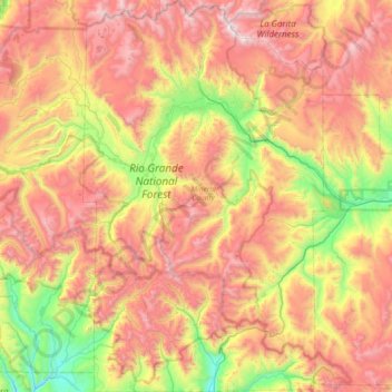
Name: Mineral County topographic map, elevation, terrain.
Location: Mineral County, Colorado, United States (37.39190 -107.14497 37.97484 -106.69183)
Average elevation: 3,202 m
Minimum elevation: 2,315 m
Maximum elevation: 4,204 m
Other topographic maps
Click on a map to view its topography, its elevation and its terrain.
Castle Rock
United States > Colorado > Douglas County
Castle Rock is located at 39°22′20″N 104°51′22″W / 39.37222°N 104.85611°W / 39.37222; -104.85611 (39.372212, −104.856090) at an elevation of 6,224 feet (1,897 m). Castle Rock is in central Colorado at the junction of Interstate 25 and State Highway 86, 28 mi (45 km) south of downtown…
Average elevation: 1,952 m
Breckenridge
United States > Colorado > Summit County
At the 2020 United States Census, the town had a total area of 6.047 square miles (15.661 km2), all of it land. The ski area has a total area of 2,880 acres (11.7 km2) of land. The elevation of Breckenridge is 9,600 feet (2,900 m) above sea level.
Average elevation: 3,072 m
Denver
Denver is in the western United States, in the South Platte River Valley on the western edge of the High Plains just east of the Front Range of the Rocky Mountains. Its downtown district is immediately east of the confluence of Cherry Creek and the South Platte River, about 12 miles (19 kilometres) east of the…
Average elevation: 1,684 m
Black Canyon of the Gunnison National Park
United States > Colorado > Montrose County
Average elevation: 2,225 m
Black Ridge Canyons Wilderness
United States > Colorado > Mesa County
The Black Ridge Canyons Wilderness (BRCW) is located in western Colorado with a small portion extending into eastern Utah, USA, within the arid Colorado Plateau region approximately 15 miles (24 km) west of Grand Junction, Colorado. The wilderness lies on the northwest flank of the Uncompahgre Plateau. It is…
Average elevation: 1,647 m