
Larbaa topographic map
Interactive map
Click on the map to display elevation.
About this map
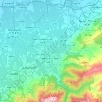
Name: Larbaa topographic map, elevation, terrain.
Location: Larbaa, Daïra Larbâa, Blida, 09300, Algérie (36.50309 3.11138 36.65347 3.23635)
Average elevation: 200 m
Minimum elevation: 19 m
Maximum elevation: 1,014 m
Other topographic maps
Click on a map to view its topography, its elevation and its terrain.
Sahraoui
Algérie > Blida > Daïra Larbâa > Larbaa
Sahraoui, Larbaa, Daïra Larbâa, Blida, 09300, Algérie
Average elevation: 90 m
Belaouadi
Algérie > Blida > Daïra Larbâa > Larbaa
Belaouadi, Larbaa, Daïra Larbâa, Blida, 16189, Algérie
Average elevation: 64 m
Aït Ghmat
Algérie > Blida > Daïra Larbâa
Aït Ghmat, Souhane, Daïra Larbâa, Blida, Algérie
Average elevation: 543 m