
Thank you for supporting this site ❤️
Make a donation
Make a donation
Praia do Cabeço topographic map
Click on the map to display elevation.
Thank you for supporting this site ❤️
Make a donation
Make a donation
About this map
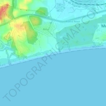
Name: Praia do Cabeço topographic map, elevation, terrain.
Location: Praia do Cabeço, Castro Marim, Faro, Portugal (37.17429 -7.47594 37.17669 -7.46206)
Average elevation: 7 m
Minimum elevation: 0 m
Maximum elevation: 48 m
Thank you for supporting this site ❤️
Make a donation
Make a donation
Other topographic maps
Click on a map to view its topography, its elevation and its terrain.
Thank you for supporting this site ❤️
Make a donation
Make a donation
Thank you for supporting this site ❤️
Make a donation
Make a donation