
Thank you for supporting this site ❤️
Make a donation
Make a donation
Odeleite topographic map
Click on the map to display elevation.
Thank you for supporting this site ❤️
Make a donation
Make a donation
About this map
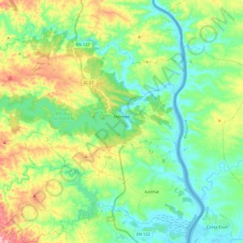
Name: Odeleite topographic map, elevation, terrain.
Location: Odeleite, Castro Marim, Faro, Portugal (37.26714 -7.63707 37.39457 -7.43634)
Average elevation: 90 m
Minimum elevation: -2 m
Maximum elevation: 295 m
Thank you for supporting this site ❤️
Make a donation
Make a donation
Other topographic maps
Click on a map to view its topography, its elevation and its terrain.
Thank you for supporting this site ❤️
Make a donation
Make a donation
Thank you for supporting this site ❤️
Make a donation
Make a donation