
黃嶺 topographic map
Interactive map
Click on the map to display elevation.
About this map
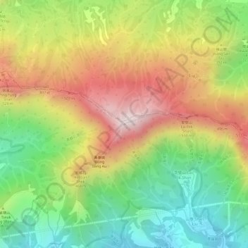
Name: 黃嶺 topographic map, elevation, terrain.
Location: 黃嶺, 新界, 大埔區, 香港, DD29 1397, 中国 (22.48918 114.20774 22.48928 114.20784)
Average elevation: 314 m
Minimum elevation: 25 m
Maximum elevation: 616 m
黃嶺是香港一座海拔639米的山峰,為香港新界東北部的最高點。黃嶺處於新界大埔區的北部,其附近範圍被劃入八仙嶺郊野公園之內。
Other topographic maps
Click on a map to view its topography, its elevation and its terrain.