
Yashio topographic map
Interactive map
Click on the map to display elevation.
About this map
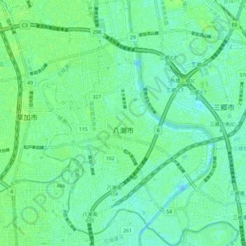
Name: Yashio topographic map, elevation, terrain.
Location: Yashio, Saitama Prefecture, Japan (35.79082 139.81142 35.85809 139.86935)
Average elevation: 5 m
Minimum elevation: -1 m
Maximum elevation: 9 m
Located in far southeastern Saitama Prefecture at an elevation of only three meters above sea level, Yashio is on the central reaches of the Naka River, and is approximately 20 kilometers from downtown Tokyo.
Other topographic maps
Click on a map to view its topography, its elevation and its terrain.
Nishi Mera
Nishi Mera, Koyu County, Miyazaki Prefecture, Japan
Average elevation: 656 m
Mount Fuji
Japan > Sunto County > Oyama
Mount Fuji, Oyama, Sunto County, Shizuoka Prefecture, Chubu Region, Japan
Average elevation: 3,261 m
Lake Ashi
Japan > Ashigarashimo County > Hakone
Lake Ashi, Hakone, Ashigarashimo County, Kanagawa Prefecture, Japan
Average elevation: 869 m
Maborikaigan 4-chome Park
Maborikaigan 4-chome Park, Maboricho 3-chome, Yokosuka, Kanagawa Prefecture, 238-8550, Japan
Average elevation: 22 m
Ibaraki
Ibaraki, Higashiibaraki County, Ibaraki Prefecture, 311-3116, Japan
Average elevation: 26 m
Lake Sanaru
Lake Sanaru, Hamamatsu, Shizuoka Prefecture, Chubu Region, Japan
Average elevation: 16 m
Motoyama
Motoyama, Nagaoka County, Kochi Prefecture, 781-3601, Japan
Average elevation: 679 m
Setouchi
Setouchi, Oshima County, Kagoshima Prefecture, Japan
Average elevation: 26 m
Higashishirakawa
Higashishirakawa, Kamo County, Gifu Prefecture, Chubu Region, 509-1392, Japan
Average elevation: 658 m
Nishikigaoka-chuo Park
Nishikigaoka-chuo Park, Nishikigaoka 2-chome, Aoba Ward, Sendai, Miyagi Prefecture, Japan
Average elevation: 197 m