
Make a donation
Oxbow Nature Preserve Lake topographic map
Click on the map to display elevation.
Make a donation
About this map
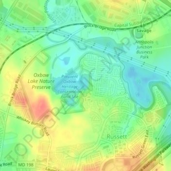
Name: Oxbow Nature Preserve Lake topographic map, elevation, terrain.
Average elevation: 55 m
Minimum elevation: 32 m
Maximum elevation: 85 m
Make a donation
Other topographic maps
Click on a map to view its topography, its elevation and its terrain.
Franklin Point State Park
United States > Maryland > Anne Arundel County > Columbia Beach
Average elevation: 1 m
Make a donation
Make a donation
Pasadena
United States > Maryland > Anne Arundel County
Pasadena is located at 39°6′46″N 76°33′7″W / 39.11278°N 76.55194°W / 39.11278; -76.55194 (39.112809, −76.551871) in northern Anne Arundel County. It is bordered to the north by the city of Baltimore, to the east by the tidal Patapsco River and by Riviera Beach, to the southeast by Lake…
Average elevation: 16 m
Make a donation
Make a donation
Make a donation
Magothy River
United States > Maryland > Anne Arundel County > Severna Park
Almost all of the creeks and tidal coves on the Magothy are named, partly as the result of a project started in 2001 by the Magothy River Association. They are shown on a map produced as part of that project, and the major ones are shown on the USGS topographic map.
Average elevation: 9 m
Cape St. Claire
United States > Maryland > Anne Arundel County > Cape Saint Claire
Average elevation: 12 m
Make a donation
Venice Beach
United States > Maryland > Anne Arundel County > Arundel on the Bay
Average elevation: 2 m
Make a donation
Make a donation
Make a donation
Make a donation
Make a donation
Highland Beach
United States > Maryland > Anne Arundel County > Highland Beach > Highland Beach
Average elevation: 3 m
Lower Magothy Beach
United States > Maryland > Anne Arundel County > Severna Park > Lower Magothy Beach
Average elevation: 9 m
Make a donation
Windrush Farm
United States > Maryland > Anne Arundel County > Severna Park > Windrush Farm
Average elevation: 10 m
Severndale
United States > Maryland > Anne Arundel County > Severna Park > Severndale
Average elevation: 18 m
Make a donation
Annapolis
United States > Maryland > Anne Arundel County > Annapolis
Annapolis lies within the humid subtropical climate zone (Köppen Cfa), with hot, humid summers, cool winters, and generous precipitation year-round. Low elevation and proximity to the Chesapeake Bay give the area more moderate spring and summertime temperatures and slightly less extreme winter lows than…
Average elevation: 13 m
Make a donation
Willowdale
United States > Maryland > Anne Arundel County > Glen Burnie > Willowdale
Average elevation: 23 m
Admirals Walk
United States > Maryland > Anne Arundel County > Cape Saint Claire
Average elevation: 12 m
Linstead-on-the-Severn
United States > Maryland > Anne Arundel County > Severna Park
Average elevation: 11 m
Make a donation
Bluff Point
United States > Maryland > Anne Arundel County > Arden on the Severn
Average elevation: 15 m
Make a donation