
峪泉镇 topographic map
Interactive map
Click on the map to display elevation.
About this map
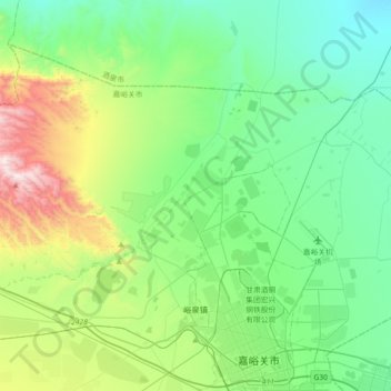
Name: 峪泉镇 topographic map, elevation, terrain.
Location: 峪泉镇, 郊区, 嘉峪关市, 甘肃省, 中国 (39.78049 97.98356 39.99469 98.34204)
Average elevation: 1,677 m
Minimum elevation: 1,361 m
Maximum elevation: 2,658 m
Other topographic maps
Click on a map to view its topography, its elevation and its terrain.