
Jhansi topographic map
Interactive map
Click on the map to display elevation.
About this map
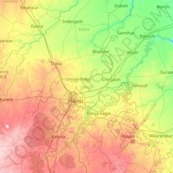
Name: Jhansi topographic map, elevation, terrain.
Location: Jhansi, Uttar Pradesh, India (25.10647 78.30086 25.95527 79.41613)
Average elevation: 232 m
Minimum elevation: 129 m
Maximum elevation: 414 m
Other topographic maps
Click on a map to view its topography, its elevation and its terrain.
Ganges
India > Uttar Pradesh > Ghazipur
The upper phase of the river Ganges begins at the confluence of the Bhagirathi and Alaknanda rivers in the town of Devprayag in the Garhwal division of the Indian state of Uttarakhand. The Bhagirathi is considered to be the source in Hindu culture and mythology, although the Alaknanda is longer, and therefore,…
Average elevation: 1,626 m