
Meerut topographic map
Interactive map
Click on the map to display elevation.
About this map
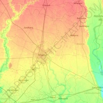
Name: Meerut topographic map, elevation, terrain.
Location: Meerut, Uttar Pradesh, India (28.73691 77.42332 29.26668 78.12487)
Average elevation: 225 m
Minimum elevation: 203 m
Maximum elevation: 246 m
Other topographic maps
Click on a map to view its topography, its elevation and its terrain.
Varanasi
India > Uttar Pradesh > Sadar
Varanasi is located at an elevation of 80.71 metres (264.8 ft) in the centre of the Ganges valley of North India, in the Eastern part of the state of Uttar Pradesh, along the left crescent-shaped bank of the Ganges, averaging between 15 metres (50 ft) and 21 metres (70 ft) above the river. The city is the…
Average elevation: 77 m