
贵州省 topographic map
Interactive map
Click on the map to display elevation.
About this map
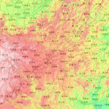
Name: 贵州省 topographic map, elevation, terrain.
Location: 贵州省, 中国 (24.62072 103.59999 29.22445 109.59400)
Average elevation: 914 m
Minimum elevation: 68 m
Maximum elevation: 2,813 m
“贵州”名称,始于宋朝。公元974年,土著首领普贵以控制的矩州归顺,宋朝在敕书中有:“惟尔贵州,远在要荒”一语,这是以贵州之名称此地区的最早记载。除此以外,還有另一種說法,指貴州的名稱源自「羅氏鬼國」;因為「鬼」不好聽,才轉音為「貴」,也有一說,因此地地形崎嶇,交通不便,運送物資不易,造成百物昂貴,故有"貴州"之名。中國彝族的先民曾被稱為「羅羅」或「羅蘇」。唐宋時代,隨着大理國崛起,彝族部落開始越過烏蒙山,在今天貴州地區廣泛發展。他們在唐末已形成較大的獨立政權,被稱為“大鬼主羅殿王”。宋末,貴州中部有羅氏鬼國,或稱為羅施鬼國,依附於宋;南部則有羅殿國,依附於大理。
Other topographic maps
Click on a map to view its topography, its elevation and its terrain.