
Thank you for supporting this site ❤️
Make a donation
Make a donation
Cotas topographic map
Click on the map to display elevation.
Thank you for supporting this site ❤️
Make a donation
Make a donation
About this map
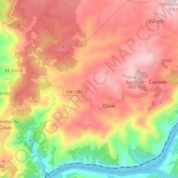
Name: Cotas topographic map, elevation, terrain.
Location: Cotas, Alijó, Vila Real, Portugal (41.19665 -7.51831 41.25042 -7.46548)
Average elevation: 439 m
Minimum elevation: 77 m
Maximum elevation: 703 m
Thank you for supporting this site ❤️
Make a donation
Make a donation
Other topographic maps
Click on a map to view its topography, its elevation and its terrain.