
Thank you for supporting this site ❤️
Make a donation
Make a donation
Bandeira topographic map
Click on the map to display elevation.
Thank you for supporting this site ❤️
Make a donation
Make a donation
About this map
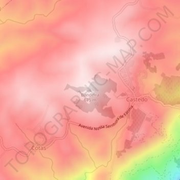
Name: Bandeira topographic map, elevation, terrain.
Location: Bandeira, Alijó, Vila Real, 5070-021, Portugal (41.22703 -7.47494 41.22713 -7.47484)
Average elevation: 546 m
Minimum elevation: 103 m
Maximum elevation: 674 m
Thank you for supporting this site ❤️
Make a donation
Make a donation
Other topographic maps
Click on a map to view its topography, its elevation and its terrain.