
Thank you for supporting this site ❤️
Make a donation
Make a donation
Freixo topographic map
Click on the map to display elevation.
Thank you for supporting this site ❤️
Make a donation
Make a donation
About this map
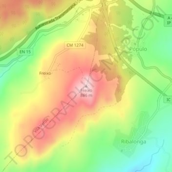
Name: Freixo topographic map, elevation, terrain.
Location: Freixo, Alijó, Vila Real, 5090-052, Portugal (41.36789 -7.51442 41.36799 -7.51432)
Average elevation: 749 m
Minimum elevation: 620 m
Maximum elevation: 878 m
Thank you for supporting this site ❤️
Make a donation
Make a donation
Other topographic maps
Click on a map to view its topography, its elevation and its terrain.