
梅家坞村 topographic map
Interactive map
Click on the map to display elevation.
About this map
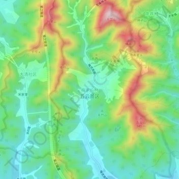
Name: 梅家坞村 topographic map, elevation, terrain.
Location: 梅家坞村, 杭州市, 浙江省, 310008, 中国 (30.18476 120.06198 30.22476 120.10198)
Average elevation: 141 m
Minimum elevation: 12 m
Maximum elevation: 383 m
Other topographic maps
Click on a map to view its topography, its elevation and its terrain.