
Northern Territory topographic map
Interactive map
Click on the map to display elevation.
Northern Territory
The fatigue resulting from long-distance driving and the hazards inherent in dirt roads, wildlife, water crossings and wild weather have led the Northern Territory Government to pursue road safety campaigns in English and several Aboriginal languages. Persuading people to drive at the right speed for the road conditions has been a key goal. As of 2021, the Northern Territory's road vehicle speed limit in built-up areas was 60 kilometres per hour unless the town had gazetted a lower default speed limit: many had chosen 50 km/h or lower. Outside most built-up areas the default speed limit was 110 km/h unless a speed limit sign stated otherwise. Reflecting the nature of the topography and very low population density, some sections of the Arnhem, Barkly, Stuart and Victoria highways had a maximum speed of 130 km/h.
About this map
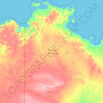
Name: Northern Territory topographic map, elevation, terrain.
Location: Northern Territory, Australia (-25.99862 129.00045 -10.85246 138.02737)
Average elevation: 230 m
Minimum elevation: -1 m
Maximum elevation: 1,123 m
Other topographic maps
Click on a map to view its topography, its elevation and its terrain.
Mount Meharry
The summit of Mt Meharry can be reached from the Great Northern Highway via an unsealed road 16 km (9.9 mi) in length and a vehicular track 21 kilometres (13 mi) in length. Permission should be sought from the managers of the land over which the road and track pass. These are Juna Downs Station and the…
Average elevation: 1,030 m
Mount Bogong
The Big River separates the massif of the mountain from the Bogong High Plains to the south. From the nearby town of Mount Beauty to its summit, Mount Bogong rises more than 1,600 metres (5,200 ft),[citation needed] thus making it one of the highest peaks in Australia not only in terms of its elevation above…
Average elevation: 1,719 m
Sydney
Australia > New South Wales > Sydney
The Hills district generally refers to the suburbs in north-western Sydney including the local government areas of The Hills Shire, parts of the City of Parramatta Council and Hornsby Shire. Actual suburbs and localities that are considered to be in the Hills District can be somewhat amorphous and variable.…
Average elevation: 34 m