
Thank you for supporting this site ❤️
Make a donation
Make a donation
Mount Bogong topographic map
Click on the map to display elevation.
Thank you for supporting this site ❤️
Make a donation
Make a donation
Mount Bogong
The Big River separates the massif of the mountain from the Bogong High Plains to the south. From the nearby town of Mount Beauty to its summit, Mount Bogong rises more than 1,600 metres (5,200 ft),[citation needed] thus making it one of the highest peaks in Australia not only in terms of its elevation above sea level, but also in terms of actual base-to-summit prominence.[citation needed]
Thank you for supporting this site ❤️
Make a donation
Make a donation
About this map
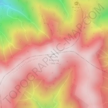
Name: Mount Bogong topographic map, elevation, terrain.
Location: Mount Bogong, Shire of East Gippsland, Victoria, Australia (-36.73242 147.30578 -36.73232 147.30588)
Average elevation: 1,719 m
Minimum elevation: 1,109 m
Maximum elevation: 1,985 m
Thank you for supporting this site ❤️
Make a donation
Make a donation
Other topographic maps
Click on a map to view its topography, its elevation and its terrain.
Thank you for supporting this site ❤️
Make a donation
Make a donation
Thank you for supporting this site ❤️
Make a donation
Make a donation