
Make a donation
Morelos topographic map
Click on the map to display elevation.
Make a donation
Morelos
Morelos, most of which is between 1,000 and 3,300 meters (3,300 and 10,800 ft) above sea level, has a very diverse topography: 42% is mountainous, 16% hilly land, and 42% flat terrain. The highest altitudes are found near the state's border with Mexico City, and the lowest are found in the Huaxtla region. The state straddles two main geographic formations, the Trans-Mexican Volcanic Belt in the north and east and the Sierra Madre del Sur, which stretches south and west from Cuernavaca and Jiutepec. The majestic mountain peaks of the Sierra Ajusco in the north of the state divide Morelos from the neighboring Valley of Mexico.
Make a donation
About this map
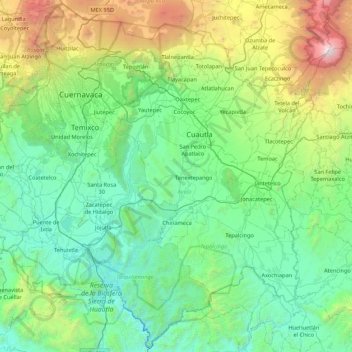
Name: Morelos topographic map, elevation, terrain.
Location: Morelos, Mexico (18.33237 -99.49441 19.13170 -98.63295)
Average elevation: 1,642 m
Minimum elevation: 718 m
Maximum elevation: 5,371 m
Make a donation
Other topographic maps
Click on a map to view its topography, its elevation and its terrain.
San Miguel el Alto
Mexico > Jalisco > San Miguel el Alto > San Miguel el Alto
Average elevation: 1,887 m
Atotonilco El Alto
Mexico > Jalisco > Atotonilco el Alto > Atotonilco El Alto
Average elevation: 1,712 m
Make a donation
Make a donation
Jilotlan de los Dolores
Mexico > Jalisco > Jilotlán de los Dolores > Jilotlan de los Dolores
Average elevation: 862 m
Make a donation
Tamazula de Gordiano
Mexico > Jalisco > Tamazula de Gordiano > Tamazula de Gordiano
Average elevation: 1,222 m
Make a donation
San Sebastián del Sur
Mexico > Jalisco > Gómez Farías > San Sebastián del Sur
Average elevation: 1,623 m
Make a donation
Paseos del Valle
Mexico > Jalisco > Tlajomulco de Zuñiga > Santa Cruz del Valle > Paseos del Valle
Average elevation: 1,532 m
Make a donation
Make a donation
San Diego de Alejandría
Mexico > Jalisco > San Diego de Alejandría > San Diego de Alejandría
Average elevation: 1,882 m
Unión de San Antonio
Mexico > Jalisco > Unión de San Antonio > Unión de San Antonio
Average elevation: 1,900 m
Make a donation
Delegación de la Pila
Mexico > San Luis Potosi > Municipio de San Luis Potosí > Delegación de la Pila
Average elevation: 1,868 m
Make a donation