
San Juan de Pastocalle topographic map
Interactive map
Click on the map to display elevation.
About this map
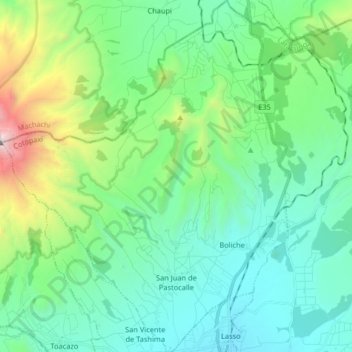
Name: San Juan de Pastocalle topographic map, elevation, terrain.
Location: San Juan de Pastocalle, Latacunga, Cotopaxi, Ecuador (-0.76017 -78.71571 -0.59718 -78.58182)
Average elevation: 3,465 m
Minimum elevation: 2,979 m
Maximum elevation: 5,205 m
Other topographic maps
Click on a map to view its topography, its elevation and its terrain.
Macaló Chico
Ecuador > Cotopaxi > Latacunga > Mulaló
Macaló Chico, Mulaló, Latacunga, Cotopaxi, Ecuador
Average elevation: 3,094 m
San Miguel
Ecuador > Cotopaxi > Latacunga > Belisario Quevedo
San Miguel, Belisario Quevedo, Latacunga, Cotopaxi, 050106, Ecuador
Average elevation: 2,759 m
El Banco de San Isisdro
Ecuador > Cotopaxi > Latacunga > Alaques
El Banco de San Isisdro, Alaques, Latacunga, Cotopaxi, Ecuador
Average elevation: 3,069 m
Pastocalle
Ecuador > Cotopaxi > Latacunga > Latacunga
Pastocalle, Latacunga, Cotopaxi, 050108, Ecuador
Average elevation: 2,851 m
Belisario Quevedo
Ecuador > Cotopaxi > Latacunga
Belisario Quevedo, Latacunga, Cotopaxi, Ecuador
Average elevation: 2,945 m
San Francisco
Ecuador > Cotopaxi > Latacunga > Toacaso > San Francisco
San Francisco, Toacaso, Latacunga, Cotopaxi, Ecuador
Average elevation: 3,288 m
Zumbalica Sur
Ecuador > Cotopaxi > Latacunga > Latacunga > La Calera Sur > Zumbalica Sur
Zumbalica Sur, La Calera Sur, Latacunga, Cotopaxi, EC050101, Ecuador
Average elevation: 2,844 m
Guaytacama
Ecuador > Cotopaxi > Latacunga
Guaytacama, Latacunga, Cotopaxi, 050109, Ecuador
Average elevation: 2,925 m
Ignacio Flores
Ecuador > Cotopaxi > Latacunga > Latacunga > Ignacio Flores
Ignacio Flores, Latacunga, Cotopaxi, +953, Ecuador
Average elevation: 2,826 m
Chugchilan
Ecuador > Cotopaxi > Latacunga > Latacunga > Chugchilan
Chugchilan, Latacunga, Cotopaxi, 050107, Ecuador
Average elevation: 2,909 m
Volcán Cotopaxi
Ecuador > Cotopaxi > Latacunga > Mulaló
Volcán Cotopaxi, Mulaló, Latacunga, Cotopaxi, Ecuador
Average elevation: 5,021 m