
Latacunga topographic map
Interactive map
Click on the map to display elevation.
About this map
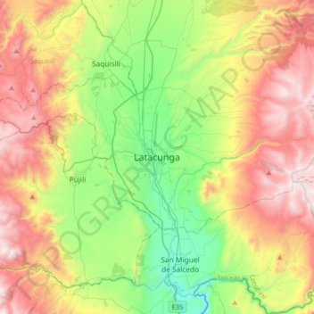
Name: Latacunga topographic map, elevation, terrain.
Location: Latacunga, Cotopaxi, 0501, Ecuador (-1.09403 -78.77458 -0.77403 -78.45458)
Average elevation: 3,213 m
Minimum elevation: 2,526 m
Maximum elevation: 4,165 m
Latacunga, también conocida como San Vicente Mártir de Latacunga, es una ciudad ecuatoriana; cabecera cantonal del Cantón Latacunga y capital de la Provincia de Cotopaxi, así como la urbe más grande y poblada de la misma. Se localiza al centro-norte de la Región interandina del Ecuador, en la hoya del río Patate, atravesada por los ríos Cutuchi y Pumacunchi, a una altitud de 2919 m s. n. m. y con un clima frío andino de 12 °C en promedio.
Other topographic maps
Click on a map to view its topography, its elevation and its terrain.
Pastocalle
Ecuador > Cotopaxi > Latacunga > Latacunga
Pastocalle, Latacunga, Cotopaxi, 050108, Ecuador
Average elevation: 2,851 m
Zumbalica Sur
Ecuador > Cotopaxi > Latacunga > Latacunga > La Calera Sur > Zumbalica Sur
Zumbalica Sur, La Calera Sur, Latacunga, Cotopaxi, EC050101, Ecuador
Average elevation: 2,844 m
Ignacio Flores
Ecuador > Cotopaxi > Latacunga > Latacunga > Ignacio Flores
Ignacio Flores, Latacunga, Cotopaxi, +953, Ecuador
Average elevation: 2,826 m
Chugchilan
Ecuador > Cotopaxi > Latacunga > Latacunga > Chugchilan
Chugchilan, Latacunga, Cotopaxi, 050107, Ecuador
Average elevation: 2,909 m