
Macaló Chico topographic map
Interactive map
Click on the map to display elevation.
About this map
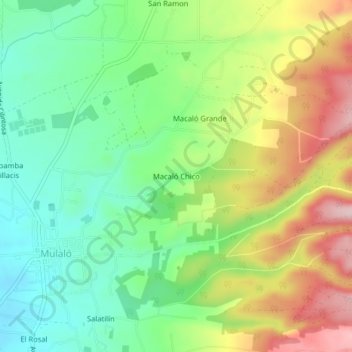
Name: Macaló Chico topographic map, elevation, terrain.
Location: Macaló Chico, Mulaló, Latacunga, Cotopaxi, Ecuador (-0.79209 -78.58196 -0.75209 -78.54196)
Average elevation: 3,094 m
Minimum elevation: 2,987 m
Maximum elevation: 3,259 m
Other topographic maps
Click on a map to view its topography, its elevation and its terrain.
Volcán Cotopaxi
Ecuador > Cotopaxi > Latacunga > Mulaló
Volcán Cotopaxi, Mulaló, Latacunga, Cotopaxi, Ecuador
Average elevation: 5,021 m