
Thank you for supporting this site ❤️
Make a donation
Make a donation
Flat Rock topographic map
Click on the map to display elevation.
Thank you for supporting this site ❤️
Make a donation
Make a donation
About this map
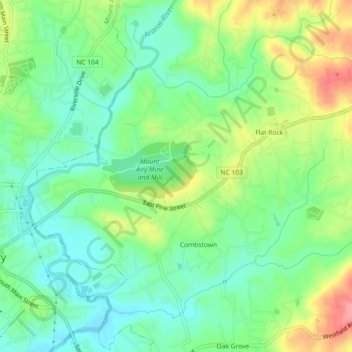
Name: Flat Rock topographic map, elevation, terrain.
Location: Flat Rock, Surry County, North Carolina, United States (36.49311 -80.60101 36.52242 -80.55549)
Average elevation: 333 m
Minimum elevation: 299 m
Maximum elevation: 391 m
Thank you for supporting this site ❤️
Make a donation
Make a donation
Other topographic maps
Click on a map to view its topography, its elevation and its terrain.
Thank you for supporting this site ❤️
Make a donation
Make a donation
Mount Airy
United States > North Carolina > Surry County > Mount Airy > Mount Airy
Average elevation: 338 m