
Thank you for supporting this site ❤️
Make a donation
Make a donation
Mulberry topographic map
Click on the map to display elevation.
Thank you for supporting this site ❤️
Make a donation
Make a donation
About this map
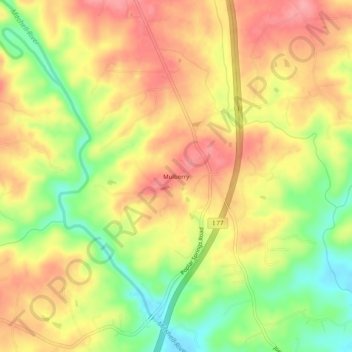
Name: Mulberry topographic map, elevation, terrain.
Location: Mulberry, Surry County, North Carolina, United States (36.30708 -80.82285 36.34708 -80.78285)
Average elevation: 341 m
Minimum elevation: 284 m
Maximum elevation: 383 m
Thank you for supporting this site ❤️
Make a donation
Make a donation
Other topographic maps
Click on a map to view its topography, its elevation and its terrain.