
Make a donation
Taneytown topographic map
Click on the map to display elevation.
Make a donation
About this map
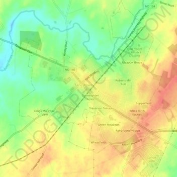
Name: Taneytown topographic map, elevation, terrain.
Location: Taneytown, Carroll County, Maryland, 21787, United States (39.63784 -77.19518 39.67910 -77.14147)
Average elevation: 153 m
Minimum elevation: 124 m
Maximum elevation: 178 m
Make a donation
Other topographic maps
Click on a map to view its topography, its elevation and its terrain.
Make a donation
Make a donation
Make a donation
Union Mills Homestead Park
United States > Maryland > Carroll County > Union Mills
Average elevation: 195 m
Make a donation
Mount Airy
United States > Maryland > Carroll County > Mount Airy > Mount Airy
The town was originally settled in the early 1830s by a core group of six families. Dorsey, Davis and Bussard were the most prominent names in that first settlement, which was followed closely by the construction of the B & O railroad line in 1831. Because Mount Airy sits at an elevation of 830 feet (250 m), a…
Average elevation: 217 m
Make a donation
Make a donation