
Thank you for supporting this site ❤️
Make a donation
Make a donation
Marston topographic map
Click on the map to display elevation.
Thank you for supporting this site ❤️
Make a donation
Make a donation
About this map
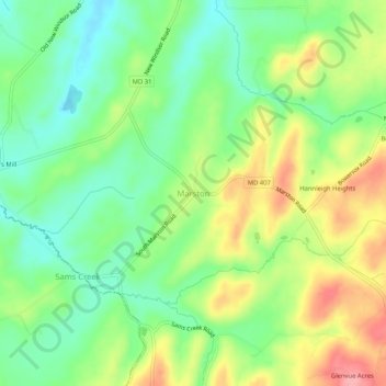
Name: Marston topographic map, elevation, terrain.
Location: Marston, Carroll County, Maryland, 21776, United States (39.48788 -77.12026 39.52788 -77.08026)
Average elevation: 189 m
Minimum elevation: 143 m
Maximum elevation: 257 m
Thank you for supporting this site ❤️
Make a donation
Make a donation
Other topographic maps
Click on a map to view its topography, its elevation and its terrain.
Avondale Wildlife Management Area
United States > Maryland > Carroll County > Chapel Heights
Average elevation: 206 m
Thank you for supporting this site ❤️
Make a donation
Make a donation