
Thank you for supporting this site ❤️
Make a donation
Make a donation
Silver Run topographic map
Click on the map to display elevation.
Thank you for supporting this site ❤️
Make a donation
Make a donation
About this map
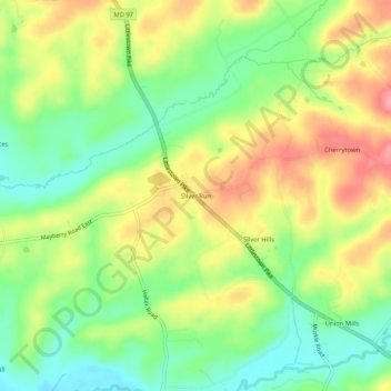
Name: Silver Run topographic map, elevation, terrain.
Location: Silver Run, Carroll County, Maryland, United States (39.66288 -77.06415 39.70288 -77.02415)
Average elevation: 198 m
Minimum elevation: 151 m
Maximum elevation: 254 m
Thank you for supporting this site ❤️
Make a donation
Make a donation
Other topographic maps
Click on a map to view its topography, its elevation and its terrain.
Avondale Wildlife Management Area
United States > Maryland > Carroll County > Chapel Heights
Average elevation: 206 m
Thank you for supporting this site ❤️
Make a donation
Make a donation